
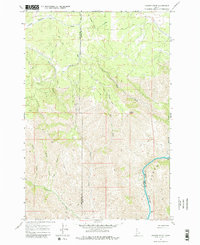
1967 Map of Hoover Point
USGS Topo · Published 1971About this map
The Salmon River cuts through the southeastern corner of this Idaho landscape, carving a deep canyon that defines the regional topography. This 1967 survey captures a remote wilderness where industry and transportation are marked by the scars of the past, most notably the winding Old RR Grade that snakes across the high ridges and through the drainages of Deer Creek. Evidence of early resource extraction is anchored by the Deer Creek Mine located in the central portion of the map.
Find a feature on this map
16 named features on this map. Tap any name to fly to it.
Don’t see what you’re looking for? This feature index may not catch every label — zoom into the map to look around manually.
Map Details
Editions of this 1967 Hoover Point Map
2 editions found
Other maps of this area

1946 · Limekiln Rapids
USGS Topo · 1:62,500

1955 · Pullman
USGS Topo · 1:250,000

1955 · Grangeville
USGS Topo · 1:250,000

1958 · Pullman
USGS Topo · 1:250,000

1959 · Grangeville
USGS Topo · 1:250,000

1963 · Boles
USGS Topo · 1:24,000

1963 · Rattlesnake Ridge
USGS Topo · 1:24,000

1963 · Wapshilla Creek
USGS Topo · 1:24,000

1967 · Westlake
USGS Topo · 1:24,000
1967 · Winchester East
USGS Topo · 1:24,000