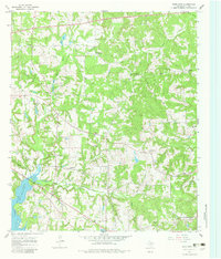
1966 Map of Hope Pond
USGS Topo · Published 1983About this map
Lake Tyler East and the meandering course of Mud Creek dominate this 1960s landscape in eastern Smith County. The settlement of Douglas sits at a central crossroads, surrounded by a rural network of small community centers identified by their local landmarks. This area is particularly dense with historic congregation sites and burial grounds, such as Chapel Hill Ch, Independance Ch, and Holt Cem. The southern edge is defined by the Missouri Pacific railroad corridor passing through Arp, reflecting the transport infrastructure of the mid-20th century.
Find a feature on this map
30 named features on this map. Tap any name to fly to it.
Don’t see what you’re looking for? This feature index may not catch every label — zoom into the map to look around manually.
Map Details
Editions of this 1966 Hope Pond Map
3 editions found
Other maps of this area

1935 · Henderson
USGS Topo · 1:48,000

1936 · Kilgore
USGS Topo · 1:48,000

1937 · Troupe
USGS Topo · 1:48,000

1938 · Winona
USGS Topo · 1:48,000

1939 · Henderson
USGS Topo · 1:62,500

1940 · Kilgore
USGS Topo · 1:62,500

1943 · Troup
USGS Topo · 1:62,500

1943 · Winona
USGS Topo · 1:62,500

1956 · Tyler
USGS Topo · 1:250,000

1966 · Hope Pond
USGS Topo · 1:24,000