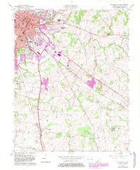
1956 Map of Hopkinsville
USGS Topo · Published 1983About this map
Hopkinsville serves as the focal point of this Christian County landscape, showing the city's mid-century footprint alongside its later growth into suburbs like Canton Heights and Morningside. The map illustrates a community anchored by public institutions and diverse transport links, from the sprawling grounds of the Western State Hospital to the Icg rail lines and the Pennyrile Parkway. Away from the urban center, the terrain is defined by the winding South Fork Little River and scattered rural settlements such as Masonville and Casky. A high density of country churches and schools, including Highland Sch and Macedonia Chapel, suggests a well-established social fabric in the surrounding farmland. The presence of the Hopkinsville Christian County Airport and the Hopkinsville Country Club reflects the local infrastructure and recreation of the post-war era.
Find a feature on this map
34 named features on this map. Tap any name to fly to it.
Don’t see what you’re looking for? This feature index may not catch every label — zoom into the map to look around manually.
Map Details
Editions of this 1956 Hopkinsville Map
3 editions found
Other maps of this area

1944 · Clarksville
USGS Topo · 1:50,000

1950 · Pembroke
USGS Topo · 1:24,000

1951 · Pembroke
USGS Topo · 1:24,000

1951 · Church Hill
USGS Topo · 1:24,000

1951 · Hopkinsville
USGS Topo · 1:24,000

1951 · Hammacksville
USGS Topo · 1:24,000

1951 · Herndon
USGS Topo · 1:24,000

1951 · Oak Grove
USGS Topo · 1:24,000

1952 · Pleasant Green Hill
USGS Topo · 1:24,000

1952 · Kelly
USGS Topo · 1:24,000