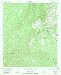
1954 Map of Hornbeck
USGS Topo · Published 1982About this map
The Kansas City Southern corridor defines the settled eastern edge of this landscape, anchoring the community of Hornbeck during the mid-1950s. While the railroad remained active, a dismantled railroad traces an older path through the western timberlands, reflecting the shifting industrial needs of the parish. The terrain is deeply dissected by numerous watercourses like Bayou Toro and Nashes Creek, creating a complex network of ridges and bottoms. This rural survey is particularly valuable for its documentation of local landmarks and lineage sites, including Saint Lukes Cemetery, Beckham Cemetery, and the Monks Hammock area. The transition of social centers is evident in the presence of both the Pleasant View Church and the New Pleasant View Church, providing a specific record of community growth and migration within Vernon Parish.
Find a feature on this map
27 named features on this map. Tap any name to fly to it.
Don’t see what you’re looking for? This feature index may not catch every label — zoom into the map to look around manually.
Map Details
Editions of this 1954 Hornbeck Map
2 editions found
Other maps of this area

1941 · Leesville
USGS Topo · 1:62,500

1942 · Florien
USGS Topo · 1:62,500

1943 · Leesville
USGS Topo · 1:62,500

1944 · Negreet
USGS Topo · 1:62,500

1944 · Wiergate
USGS Topo · 1:62,500

1944 · Florien
USGS Topo · 1:62,500

1946 · Leesville
USGS Topo · 1:62,500

1948 · Leesville
USGS Topo · 1:62,500

1948 · Wiergate
USGS Topo · 1:62,500

1953 · Alexandria
USGS Topo · 1:250,000