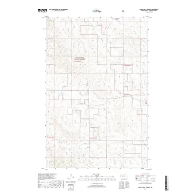
2017 Map of Horse Creek School
USGS Topo · Published 2017About this map
Little Missouri National Grassland dominates this corner of McKenzie County, where the high plains are carved by the drainage networks of Horse Cr, Cheney Cr, and Alkali Cr. This 2017 topographic survey highlights a landscape where traditional ranching geography meets modern industrial infrastructure, as evidenced by the presence of Oil Field Rd cutting across the sections. The rural character of the region is anchored by the eponymous Horse Creek School, a vital landmark for local history and genealogy in this sparsely settled area. To the north, the terrain is marked by Vanderhoof Coulee, illustrating the complex erosional patterns typical of the Badlands fringe. The map clearly delineates the section lines of Township 148 and 149 North, providing a precise framework for understanding land use and public land boundaries in western North Dakota.
Find a feature on this map
12 named features on this map. Tap any name to fly to it.
Don’t see what you’re looking for? This feature index may not catch every label — zoom into the map to look around manually.
Map Details
Editions of this 2017 Horse Creek School Map
This is the sole edition of this map. No revisions or reprints were ever made.
Other maps of this area

1909 · Glendive
USGS Topo · 1:250,000

1953 · Watford City
USGS Topo · 1:250,000

1954 · Glendive
USGS Topo · 1:250,000

1957 · Glendive
USGS Topo · 1:250,000

1957 · Watford City
USGS Topo · 1:250,000

1958 · Glendive
USGS Topo · 1:250,000

1966 · Sidney NE
USGS Topo · 1:24,000

1967 · Watford City
USGS Topo · 1:250,000

1972 · Horse Creek School
USGS Topo · 1:24,000
1972 · Fairview
USGS Topo · 1:24,000