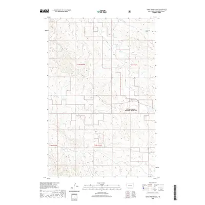
2020 Map of Horse Creek School
USGS Topo · Published 2020About this map
Horse Creek School stands as a focal point in this sparsely populated stretch of McKenzie County, North Dakota, where the prairie landscape is defined by the drainages of Horse Cr, Cheney Cr, and Alkali Cr. The northern portion of the map is marked by the distinct topographic feature Vanderhoof Coulee, while the southern expanse transition into the protected territory of the Little Missouri National Grassland. The presence of Oil Field Rd indicates the intersection of agricultural heritage and modern energy extraction in the Badlands region. Navigating this rural terrain relies on established routes like Co Rd 3, which connects isolated ranching interests and section lines throughout this rugged North Dakota interior.
Find a feature on this map
12 named features on this map. Tap any name to fly to it.
Don’t see what you’re looking for? This feature index may not catch every label — zoom into the map to look around manually.
Map Details
Editions of this 2020 Horse Creek School Map
This is the sole edition of this map. No revisions or reprints were ever made.
Other maps of this area

1909 · Glendive
USGS Topo · 1:250,000

1953 · Watford City
USGS Topo · 1:250,000

1954 · Glendive
USGS Topo · 1:250,000

1957 · Glendive
USGS Topo · 1:250,000

1957 · Watford City
USGS Topo · 1:250,000

1958 · Glendive
USGS Topo · 1:250,000

1966 · Sidney NE
USGS Topo · 1:24,000

1967 · Watford City
USGS Topo · 1:250,000

1972 · Horse Creek School
USGS Topo · 1:24,000
1972 · Fairview
USGS Topo · 1:24,000