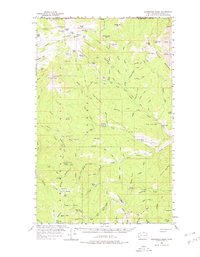
1956 Map of Horseshoe Basin
USGS Topo · Published 1978About this map
Horseshoe Basin sits along the international boundary between the United States and Canada, anchoring a high-altitude landscape of the Okanogan National Forest as it appeared in the mid-1950s. This survey records a network of primitive backcountry sites used by foresters and hunters, including Coyote Camp, Lone Wolf Camp, and the Duncan James Cabin. The terrain is defined by dramatic peaks and ridges, from Chopaka Mountain in the northeast to the heights of Windy Peak and Thunder Mtn.
Find a feature on this map
114 named features on this map. Tap any name to fly to it.
Don’t see what you’re looking for? This feature index may not catch every label — zoom into the map to look around manually.
Map Details
Editions of this 1956 Horseshoe Basin Map
3 editions found
Other maps of this area

1906 · Chopaka
USGS Topo · 1:125,000

1954 · Okanogan
USGS Topo · 1:250,000

1955 · Concrete
USGS Topo · 1:250,000

1956 · Loomis
USGS Topo · 1:62,500

1956 · Tiffany Mountain
USGS Topo · 1:62,500

1956 · Horseshoe Basin
USGS Topo · 1:62,500

1957 · Conconully
USGS Topo · 1:62,500

1958 · Concrete
USGS Topo · 1:250,000

1958 · Okanogan
USGS Topo · 1:250,000

1962 · Concrete
USGS Topo · 1:250,000