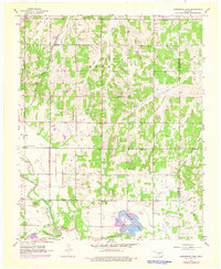
1956 Map of Horseshoe Lake
USGS Topo · Published 1976About this map
The North Canadian River winds through the southern reaches of this landscape, its floodplains defining the local topography alongside Choctaw Creek. The industrial presence at Horseshoe Lake stands out significantly, marked by a Powerplant, Substation, and several towers, indicating the area's role in regional utility infrastructure. Rural life in the mid-20th century is anchored by decentralized community hubs, including State Center Sch, Douglas Sch, and St Paul Ch.
Find a feature on this map
26 named features on this map. Tap any name to fly to it.
Don’t see what you’re looking for? This feature index may not catch every label — zoom into the map to look around manually.
Map Details
Editions of this 1956 Horseshoe Lake Map
4 editions found

Other maps of this area

1892 · Moore
USGS Topo · 1:62,500

1892 · Edmond
USGS Topo · 1:62,500

1898 · Purcell
USGS Topo · 1:125,000

1909 · Luther
USGS Topo · 1:62,500

1930 · McLoud
USGS Topo · 1:62,500

1934 · Moore
USGS Topo · 1:62,500

1935 · Edmond
USGS Topo · 1:48,000

1938 · Moore
USGS Topo · 1:62,500

1940 · Edmond
USGS Topo · 1:62,500

1954 · Oklahoma City
USGS Topo · 1:250,000