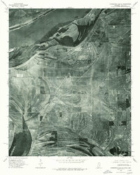
1975 Map of Horseshoe Lake SE
USGS Topo · Published 1976About this map
Robinsonville and the surrounding delta lowlands of Tunica County appear in high-resolution detail on this 1975 orthophotoquad. Unlike traditional topographic maps, this aerial imagery reveals the precise texture of the agricultural landscape, from individual field boundaries and drainage patterns to the wooded banks of the Mississippi River. The settlement pattern follows the linear orientation of regional transport corridors, with Bowdre, Penton, and Clack serving as focal points for the rural community. The imagery provides a clear view of the river's massive meanders and point bars, illustrating the hydrological forces that shaped this corner of Mississippi and Arkansas. For local historians and researchers, the map offers a clear visual record of mid-century land use and rural development before the expansion of modern industrial and recreational infrastructure.
Find a feature on this map
5 named features on this map. Tap any name to fly to it.
Don’t see what you’re looking for? This feature index may not catch every label — zoom into the map to look around manually.
Map Details
Editions of this 1975 Horseshoe Lake SE Map
2 editions found
Other maps of this area

1908 · Hollywood
USGS Topo · 1:24,000

1908 · Lake Cormorant
USGS Topo · 1:24,000

1912 · Lake Cormorant
USGS Topo · 1:31,680

1913 · Hollywood
USGS Topo · 1:31,680

1931 · Horseshoe Lake
USGS Topo · 1:62,500

1932 · Horn Lake
USGS Topo · 1:48,000

1932 · Crenshaw
USGS Topo · 1:62,500

1935 · Crenshaw
USGS Topo · 1:62,500

1935 · Horn Lake
USGS Topo · 1:62,500

1939 · Clayton
USGS Topo · 1:62,500