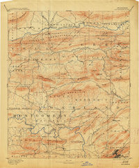
1894 Map of Hot Springs
USGS Topo · Published 1913About this map
Hot Springs serves as the focal point of this late-nineteenth-century survey, situated at the base of West Mountain and near the prominent geological feature known as The Gorge. The landscape is defined by the sharp ridges of the Fourche Mountains and the winding paths of the Ouachita River and Fourche La Fave River. Settlement patterns follow these river valleys and mountain gaps, with established points like Wards Crossing and Buckville anchoring local commerce and travel.
Find a feature on this map
81 named features on this map. Tap any name to fly to it.
Don’t see what you’re looking for? This feature index may not catch every label — zoom into the map to look around manually.
Map Details
Editions of this 1894 Hot Springs Map
5 editions found

Other maps of this area

1879 · Mountain Home
USGS Topo · 1:62,500

1887 · Magazine Mountain #4
USGS Topo · 1:62,500

1887 · Magazine Mountain
USGS Topo · 1:62,500

1888 · Dardanelle #4
USGS Topo · 1:62,500

1888 · Dardanelle #3
USGS Topo · 1:62,500

1889 · Morrilton No. 3
USGS Topo · 1:62,500

1890 · Magazine Mountain
USGS Topo · 1:125,000

1890 · Mount Ida
USGS Topo · 1:125,000

1890 · Benton
USGS Topo · 1:125,000

1890 · Hot Springs
USGS Topo · 1:125,000