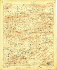
1894 Map of Hot Springs
USGS Topo · Published 1924About this map
The Ouachita River snakes through the southern portion of this Arkansas survey, where the burgeoning settlement of Hot Springs sits at the foot of West Mtn. This turn-of-the-century landscape is defined by the sharp ridges of the Fourche Mountains and the winding course of the Fourche La Fave River to the north. Extensive federal landholdings are already established, including the Arkansas National Forest and the Hot Springs Nat Park, preserving the area’s unique topography.
Find a feature on this map
83 named features on this map. Tap any name to fly to it.
Don’t see what you’re looking for? This feature index may not catch every label — zoom into the map to look around manually.
Map Details
Editions of this 1894 Hot Springs Map
5 editions found

Other maps of this area

1879 · Mountain Home
USGS Topo · 1:62,500

1887 · Magazine Mountain #4
USGS Topo · 1:62,500

1887 · Magazine Mountain
USGS Topo · 1:62,500

1888 · Dardanelle #4
USGS Topo · 1:62,500

1888 · Dardanelle #3
USGS Topo · 1:62,500

1889 · Morrilton No. 3
USGS Topo · 1:62,500

1890 · Magazine Mountain
USGS Topo · 1:125,000

1890 · Mount Ida
USGS Topo · 1:125,000

1890 · Benton
USGS Topo · 1:125,000

1890 · Hot Springs
USGS Topo · 1:125,000