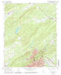
1966 Map of Hot Springs North
USGS Topo · Published 1989About this map
Hot Springs National Park dominates the southern landscape of this 1966 survey, where the urban development of Hot Springs meets the steep ridgelines of North Mountain and Hot Springs Mountain. The map reveals a dense network of local institutions, including Ouachita Hospital, the St Joseph Hospital, and several religious schools like Second Baptist Sch and St Michaels Sch. To the northeast, the terrain shifts towards the South Fork Saline River, where the small settlement of Ozark Lithia and the Ozark Cem mark a quieter, more rural character. This edition, photorevised in 1976, shows the expansion of residential areas such as Euclid Heights and Morning Star. The presence of the Missouri Pacific and Chicago Rock Island and Pacific railroads highlights the historical importance of rail transit to this resort city. Further north, isolated family landmarks like Robbins Cem and McGill Cem sit along the slopes of Glazypeau Mountain.
Find a feature on this map
65 named features on this map. Tap any name to fly to it.
Don’t see what you’re looking for? This feature index may not catch every label — zoom into the map to look around manually.
Map Details
Editions of this 1966 Hot Springs North Map
4 editions found
Other maps of this area

1890 · Benton
USGS Topo · 1:125,000

1890 · Hot Springs
USGS Topo · 1:125,000

1894 · Hot Springs
USGS Topo · 1:125,000

1894 · Benton
USGS Topo · 1:125,000

1948 · Malvern
USGS Topo · 1:62,500

1949 · Malvern
USGS Topo · 1:62,500

1955 · Little Rock
USGS Topo · 1:250,000

1956 · Little Rock
USGS Topo · 1:250,000

1960 · Little Rock
USGS Topo · 1:250,000

1964 · Little Rock
USGS Topo · 1:250,000