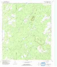
1967 Map of House Mountain
USGS Topo · Published 1992About this map
The boundary between Mason and Llano counties cuts through this rugged Texas Hill Country terrain, where water sources dictated the movement of early settlers. Granite landmarks like House Mountain and Putman Mountain dominate the landscape, providing orientation for ranchers and travelers in the late 1960s. The presence of House Mountain Spring and several named watercourses, such as Meusebach Creek and Marschall Creek, highlights the importance of reliable water in this livestock-heavy region. For local historians and genealogists, the map preserves the location of the Putman Cemetery and the notable Lovers Rock landmark. The intricate drainage network, including Blockhouse Creek and Left Hand Creek, illustrates the natural barriers and conduits that shaped the local transportation and property lines long before the era of major paved thoroughfares.
Find a feature on this map
28 named features on this map. Tap any name to fly to it.
Don’t see what you’re looking for? This feature index may not catch every label — zoom into the map to look around manually.
Map Details
Editions of this 1967 House Mountain Map
This is the sole edition of this map. No revisions or reprints were ever made.
Other maps of this area

1887 · Llano
USGS Topo · 1:125,000

1887 · Mason
USGS Topo · 1:125,000

1894 · Mason
USGS Topo · 1:125,000

1894 · Fredericksburg
USGS Topo · 1:125,000

1894 · Kerrville
USGS Topo · 1:125,000

1894 · Llano
USGS Topo · 1:125,000

1904 · Llano
USGS Topo · 1:125,000

1909 · Llano
USGS Topo · 1:125,000

1918 · Llano
USGS Topo · 1:125,000

1954 · Llano
USGS Topo · 1:250,000