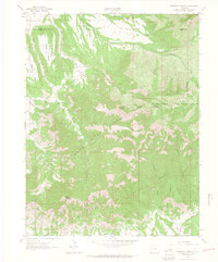
1962 Map of Housetop Mountain
USGS Topo · Published 1964About this map
Housetop Mountain and Horse Mountain anchor this high-altitude landscape within the White River National Forest and Grand Mesa National Forest. The topography is defined by the steep transition from prominent flat-topped landforms like Battlement Mesa and Samson Mesa into a complex system of drainages. Waterways such as Alkali Creek, Wallace Creek, and its North Fork Wallace Creek have carved deep incisions into the plateau, creating a network of named gulches including Durant Gulch, Bear Gulch, and Horsethief Gulch.
Find a feature on this map
29 named features on this map. Tap any name to fly to it.
Don’t see what you’re looking for? This feature index may not catch every label — zoom into the map to look around manually.
Map Details
Editions of this 1962 Housetop Mountain Map
4 editions found
Other maps of this area

1929 · Grand Valley
USGS Topo · 1:62,500

1955 · Collbran
USGS Topo · 1:24,000

1955 · Mesa
USGS Topo · 1:24,000

1955 · Molina
USGS Topo · 1:24,000

1956 · Grand Junction
USGS Topo · 1:250,000

1957 · Leadville
USGS Topo · 1:250,000

1959 · Grand Junction
USGS Topo · 1:250,000

1959 · Leadville
USGS Topo · 1:250,000

1960 · Leadville
USGS Topo · 1:250,000

1960 · Grand Junction
USGS Topo · 1:250,000