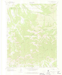
1962 Map of Housetop Mountain
USGS Topo · Published 1975About this map
Housetop Mountain and Horse Mountain anchor this high-altitude landscape along the Garfield and Mesa County border in Western Colorado. The topography is defined by the massive basalt-capped highlands of Battlement Mesa to the north and Grand Mesa to the south. Between these prominent plateaus, the land is deeply incised by a network of drainage basins and gulches, including Bull Basin and Lugans Basin.
Find a feature on this map
33 named features on this map. Tap any name to fly to it.
Don’t see what you’re looking for? This feature index may not catch every label — zoom into the map to look around manually.
Map Details
Editions of this 1962 Housetop Mountain Map
4 editions found
Other maps of this area

1929 · Grand Valley
USGS Topo · 1:62,500

1955 · Collbran
USGS Topo · 1:24,000

1955 · Mesa
USGS Topo · 1:24,000

1955 · Molina
USGS Topo · 1:24,000

1956 · Grand Junction
USGS Topo · 1:250,000

1957 · Leadville
USGS Topo · 1:250,000

1959 · Grand Junction
USGS Topo · 1:250,000

1959 · Leadville
USGS Topo · 1:250,000

1960 · Leadville
USGS Topo · 1:250,000

1960 · Grand Junction
USGS Topo · 1:250,000