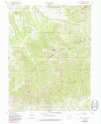
1962 Map of Housetop Mountain
USGS Topo · Published 1986About this map
Housetop Mountain serves as a prominent landmark within this high-elevation landscape, where the administrative boundaries of the White River National Forest and the Grand Mesa National Forest converge. Mapped in the early 1960s, the terrain is defined by massive plateau features like Battlement Mesa and Samson Mesa, which are dissected by an intricate network of drainages including Wallace Creek and Alkali Creek. The map documents a rugged interior accessible largely by a single Jeep Trail, highlighting the isolation of the high country between the Garfield and Mesa county lines. Natural depressions and summits such as Bull Basin, Lugans Basin, and the nearly 10,000-foot heights of Horse Mountain provide specific points of interest for those studying the physical geography and ranching history of the Western Slope. Numerous springs and deep-cut channels like Horsethief Gulch and Bear Gulch illustrate the complex watershed management within these protected forest lands.
Find a feature on this map
30 named features on this map. Tap any name to fly to it.
Don’t see what you’re looking for? This feature index may not catch every label — zoom into the map to look around manually.
Map Details
Editions of this 1962 Housetop Mountain Map
4 editions found
Other maps of this area

1929 · Grand Valley
USGS Topo · 1:62,500

1955 · Collbran
USGS Topo · 1:24,000

1955 · Mesa
USGS Topo · 1:24,000

1955 · Molina
USGS Topo · 1:24,000

1956 · Grand Junction
USGS Topo · 1:250,000

1957 · Leadville
USGS Topo · 1:250,000

1959 · Grand Junction
USGS Topo · 1:250,000

1959 · Leadville
USGS Topo · 1:250,000

1960 · Leadville
USGS Topo · 1:250,000

1960 · Grand Junction
USGS Topo · 1:250,000