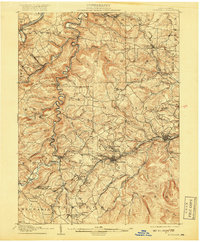
1905 Map of Houtzdale
USGS Topo · Published 1918About this map
Houtzdale serves as the central hub of this 1905 landscape, which is heavily defined by the coal and timber industries of Clearfield County. The region is a dense network of rail lines and industrial junctions, including the Pennsylvania RR and the Clearfield and Southern RR. These lines wind through the steep terrain to reach small company towns and post offices like Oshanter P.O. Mitchells and West Decatur P.O. Blue Ball. Along the banks of Clearfield Creek, several mill sites such as Belsena Mills highlight the processing of local resources before they were transported via the complex railway junctions like Moshannon Junc. and Goss Run Junc.. To the north, the West Branch Susquehanna River cuts through the townships of Lawrence and Bradford, providing a natural corridor for early development at Clearfield and Hyde.
Find a feature on this map
94 named features on this map. Tap any name to fly to it.
Don’t see what you’re looking for? This feature index may not catch every label — zoom into the map to look around manually.
Map Details
Editions of this 1905 Houtzdale Map
5 editions found
Other maps of this area

1902 · Patton
USGS Topo · 1:62,500

1903 · Curwensville
USGS Topo · 1:62,500

1903 · Houtzdale
USGS Topo · 1:62,500

1904 · Patton
USGS Topo · 1:62,500

1905 · Houtzdale
USGS Topo · 1:62,500

1920 · Altoona
USGS Topo · 1:62,500

1922 · Philipsburg
USGS Topo · 1:62,500

1922 · Altoona
USGS Topo · 1:62,500

1923 · Tyrone
USGS Topo · 1:62,500

1929 · Tyrone
USGS Topo · 1:48,000