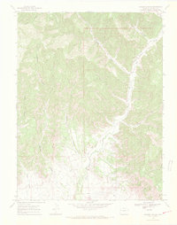
1968 Map of Howard Canyon
USGS Topo · Published 1971About this map
Salt Creek and its tributary East Salt Creek carve a complex system of drainages through this high-altitude landscape in the late 1960s. The terrain is defined by a dense network of steep-walled canyons, including Howard Canyon, Demaree Canyon, and Spink Canyon, which channel water toward the primary creek beds. Human activity in this remote region is largely centered on resource extraction and seasonal ranching, evidenced by the presence of a Gas Well, several Drill Holes, and a Gravel Pit.
Find a feature on this map
17 named features on this map. Tap any name to fly to it.
Don’t see what you’re looking for? This feature index may not catch every label — zoom into the map to look around manually.
Map Details
Editions of this 1968 Howard Canyon Map
3 editions found
Other maps of this area

1956 · Grand Junction
USGS Topo · 1:250,000

1959 · Grand Junction
USGS Topo · 1:250,000

1960 · Grand Junction
USGS Topo · 1:250,000

1962 · Grand Junction
USGS Topo · 1:250,000

1964 · Grand Junction
USGS Topo · 1:250,000

1964 · Douglas Pass
USGS Topo · 1:24,000

1964 · Baxter Pass
USGS Topo · 1:24,000

1964 · Calf Canyon
USGS Topo · 1:24,000

1965 · Grand Junction
USGS Topo · 1:250,000

1968 · Badger Wash
USGS Topo · 1:24,000