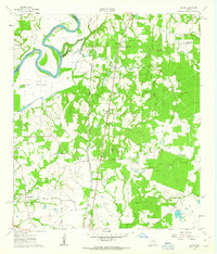
1961 Map of Howth
USGS Topo · Published 1963About this map
The Brazos River forms a sweeping meander in the northwest corner of this 1960s survey, marking the boundary between Washington and Waller Counties. This rural landscape is defined by the Southern Pacific railroad line, which runs north-south through the settlement of Howth. The area's social history is recorded through several small communities and their spiritual centers, including Rock Island with its associated Rock Island Ch and Rock Island Cem, and Second Corinth. A network of creeks like Donahoe Creek and Sandy Creek drain the wooded terrain toward the river bottom. Numerous Gravel Pit operations near the rail line indicate the local extraction industry of the era, while scattered landmarks such as Brown College and the Salem Cem provide specific points of interest for genealogical research and local history mapping.
Find a feature on this map
36 named features on this map. Tap any name to fly to it.
Don’t see what you’re looking for? This feature index may not catch every label — zoom into the map to look around manually.
Map Details
Editions of this 1961 Howth Map
2 editions found
Other maps of this area

1914 · Navasota
USGS Topo · 1:62,500

1920 · Waller
USGS Topo · 1:31,680

1954 · Beaumont
USGS Topo · 1:250,000

1954 · Austin
USGS Topo · 1:250,000

1956 · Hempstead
USGS Topo · 1:62,500

1957 · Beaumont
USGS Topo · 1:250,000

1958 · Washington
USGS Topo · 1:24,000

1958 · Courtney
USGS Topo · 1:24,000

1960 · Waller
USGS Topo · 1:24,000

1960 · Waller NW
USGS Topo · 1:24,000