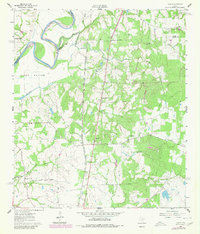
1961 Map of Howth
USGS Topo · Published 1980About this map
The Brazos River forms a sweeping boundary in the northwest corner of this quadrangle, where the fertile Clark Bottom once supported rural life at Brown College. The landscape is a network of small settlements and family hubs connected by the Southern Pacific rail line, which runs north-south through the community of Howth. This area is characterized by numerous country churches and cemeteries, such as Second Corinth Ch and Rock Island Cem, indicating a well-established social fabric of rural congregations and family burial grounds.
Find a feature on this map
35 named features on this map. Tap any name to fly to it.
Don’t see what you’re looking for? This feature index may not catch every label — zoom into the map to look around manually.
Map Details
Editions of this 1961 Howth Map
2 editions found
Other maps of this area

1914 · Navasota
USGS Topo · 1:62,500

1920 · Waller
USGS Topo · 1:31,680

1954 · Beaumont
USGS Topo · 1:250,000

1954 · Austin
USGS Topo · 1:250,000

1956 · Hempstead
USGS Topo · 1:62,500

1957 · Beaumont
USGS Topo · 1:250,000

1958 · Washington
USGS Topo · 1:24,000

1958 · Courtney
USGS Topo · 1:24,000

1960 · Waller
USGS Topo · 1:24,000

1960 · Waller NW
USGS Topo · 1:24,000