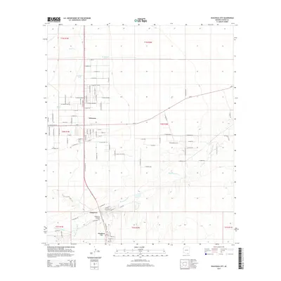
2014 Map of Huachuca City
USGS Topo · Published 2014About this map
Huachuca City anchors the southern portion of this landscape, situated near the mouth of Huachuca Canyon where the high desert terrain transitions toward the Babocomari River. This 2014 survey illustrates a region defined by scattered residential growth and significant water management infrastructure, evidenced by features like Boedecker Tank, Homestead Tank, and Road Tank. The community of Whetstone occupies the central corridor, organized around the junction of Az-90 and Az-82. To the east, the Whetstone Airport serves as a local aviation landmark, while the ephemeral Slaughter House Wash and Mescal Cr drain the surrounding basin. The mapping of small residential roads such as N Calle Tercero and E Camino De Mesa provides a clear view of local development patterns in this part of Cochise County during the early 21st century.
Find a feature on this map
100 named features on this map. Tap any name to fly to it.
Don’t see what you’re looking for? This feature index may not catch every label — zoom into the map to look around manually.
Map Details
Editions of this 2014 Huachuca City Map
This is the sole edition of this map. No revisions or reprints were ever made.
Other maps of this area

1915 · Benson
USGS Topo · 1:125,000

1922 · St. David
USGS Topo · 1:62,500

1926 · Whetstone
USGS Topo · 1:62,500

1932 · Fairbank
USGS Topo · 1:62,500

1938 · Huachuca
USGS Topo · 1:62,500

1943 · Benson
USGS Topo · 1:125,000

1948 · Fort Huachuca NE
USGS Topo · 1:24,000
1948 · Mustang Mountains
USGS Topo · 1:24,000
1948 · Fort Huachuca SW
USGS Topo · 1:24,000
1948 · Fort Huachuca
USGS Topo · 1:24,000