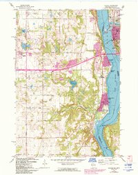
1967 Map of Hudson
USGS Topo · Published 1993About this map
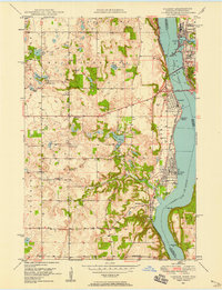
The St Croix River serves as the focal point for this survey, dividing the waterfront communities of Hudson and North Hudson in Wisconsin from the burgeoning residential corridors of Lakeland and Afton in Minnesota. The mapping reflects a landscape in transition during the early 1990s, where suburban expansion marked in purple tint meets established agricultural and historic sites. Genealogical value is found in the scattered landmarks of early settlement, including Rentz Cem, St Peters Ch, and the Mound Prairie Cem near Valley Creek. Of particular interest are the Bissells Mounds, indicating much deeper history along the river bluffs. Cultural landmarks of the late 20th century, such as the Drive-in Theater and Lake Elmo Airport, appear alongside protected natural spaces like Afton State Park and the varied inlets of Lake Mallalieu.
Find a feature on this map
49 named features on this map. Tap any name to fly to it.
Don’t see what you’re looking for? This feature index may not catch every label — zoom into the map to look around manually.
Map Details
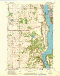
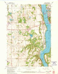
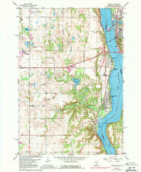
Editions of this 1967 Hudson Map
4 editions found
Other maps of this area

1946 · Hudson
USGS Topo · 1:62,500

1946 · River Falls
USGS Topo · 1:62,500

1948 · New Richmond
USGS Topo · 1:62,500

1948 · Stillwater
USGS Topo · 1:62,500

1949 · New Richmond
USGS Topo · 1:62,500

1949 · River Falls
USGS Topo · 1:62,500

1949 · Hudson
USGS Topo · 1:62,500

1949 · Stillwater
USGS Topo · 1:62,500

1949 · Lake Elmo
USGS Topo · 1:24,000
1949 · Hudson
USGS Topo · 1:24,000