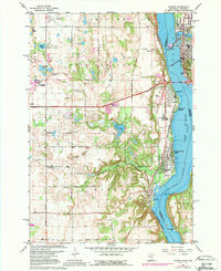
1967 Map of Hudson
USGS Topo · Published 1988About this map
The St Croix River serves as the central artery for this border region between Minnesota and Wisconsin, defining the character of the growing communities along its banks. The map reveals a post-war landscape transitioning from rural townships like West Lakeland and Baytown to burgeoning riverfront settlements such as Lakeland Shores and Lake St Croix Beach. Transportation networks are prominent, featuring the Chicago and North Western and Chicago Milwaukee St Paul and Pacific railroads following the river valley, alongside the Lake Elmo Airport further inland.
Find a feature on this map
52 named features on this map. Tap any name to fly to it.
Don’t see what you’re looking for? This feature index may not catch every label — zoom into the map to look around manually.
Map Details
Editions of this 1967 Hudson Map
4 editions found
Other maps of this area

1946 · Hudson
USGS Topo · 1:62,500

1946 · River Falls
USGS Topo · 1:62,500

1948 · New Richmond
USGS Topo · 1:62,500

1948 · Stillwater
USGS Topo · 1:62,500

1949 · New Richmond
USGS Topo · 1:62,500

1949 · River Falls
USGS Topo · 1:62,500

1949 · Hudson
USGS Topo · 1:62,500

1949 · Stillwater
USGS Topo · 1:62,500

1949 · Lake Elmo
USGS Topo · 1:24,000

1949 · Hudson
USGS Topo · 1:24,000