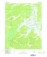
1955 Map of Hughes A-1
USGS Topo · Published 1982About this map
The Sushgitit Hills dominate the southern landscape of this interior Alaska territory, where the complex drainage patterns of the Mentanontli River and its tributaries define the region. In this mid-century environment, water is the primary architect of the land, visible through the meandering paths of Slathtouka Creek and Notoniono Creek. A notable geological marker, a Pingo, appears near the center of the sheet, indicating the presence of permafrost and the unique subarctic conditions of the Yukon-Koyukuk area. The map includes the Kateel River Meridian boundary, a critical reference point for surveying this portion of the Alaskan wilderness. Human presence is sparse, represented primarily by the Vabm 1987 Shelter and the Indian River corridor, reflecting a period when this vast interior remained largely untouched by permanent settlements or road infrastructure.
Find a feature on this map
10 named features on this map. Tap any name to fly to it.
Don’t see what you’re looking for? This feature index may not catch every label — zoom into the map to look around manually.
Map Details
Editions of this 1955 Hughes A-1 Map
3 editions found
Other maps of this area

1951 · Hughes
USGS Topo · 1:250,000

1951 · Melozitna
USGS Topo · 1:250,000

1951 · Bettles
USGS Topo · 1:250,000

1951 · Tanana
USGS Topo · 1:250,000

1952 · Melozitna D-1
USGS Topo · 1:63,360

1955 · Melozitna D-2
USGS Topo · 1:63,360

1955 · Hughes A-2
USGS Topo · 1:63,360

1955 · Hughes A-1
USGS Topo · 1:63,360

1956 · Hughes
USGS Topo · 1:250,000

1956 · Bettles
USGS Topo · 1:250,000