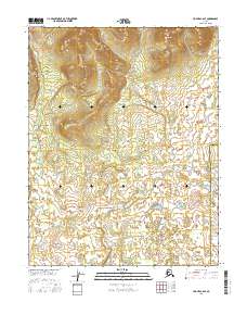
2016 Map of Hughes C-6 SE
USGS Topo · Published 2016About this map
Asiksat Cr meanders across the center of this remote landscape, defining the drainage patterns within the Northwest Arctic Borough Yukon-Koyukuk Census Area. The southern portion of the quadrangle is characterized by a cluster of water bodies known as Holly Lakes, which feed into Holly Cr as it flows toward the southeast. This 2016 survey documents a pristine interior region of Alaska, primarily organized by the Public Land Survey System grids including t14n r15e and t13n r15e. The absence of roads or permanent settlements emphasizes the wild character of this terrain, where geographic naming is limited to these significant water features and the administrative boundaries that divide the borough and census area.
Find a feature on this map
10 named features on this map. Tap any name to fly to it.
Don’t see what you’re looking for? This feature index may not catch every label — zoom into the map to look around manually.
Map Details
Editions of this 2016 Hughes C-6 SE Map
This is the sole edition of this map. No revisions or reprints were ever made.
Other maps of this area

1951 · Hughes
USGS Topo · 1:250,000

1956 · Hughes
USGS Topo · 1:250,000

1964 · Hughes
USGS Topo · 1:250,000

1965 · Hughes
USGS Topo · 1:250,000
1986 · Hughes B-5
USGS Topo · 1:63,360
1986 · Hughes B-6
USGS Topo · 1:63,360
1986 · Hughes C-5
USGS Topo · 1:63,360
1986 · Hughes C-6
USGS Topo · 1:63,360
2016 · Hughes B-5 NW
USGS Topo · 1:25,000
2016 · Hughes B-6 NE
USGS Topo · 1:25,000