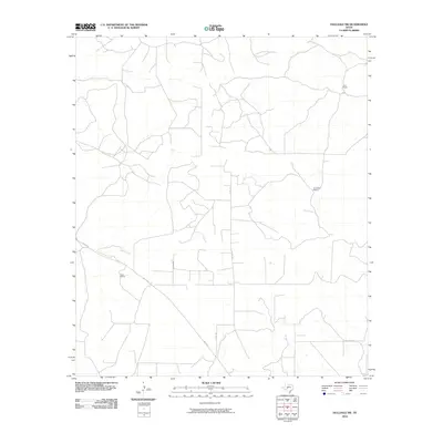
2010 Map of Hulldale SW
USGS Topo · Published 2010About this map
Duff Ranch and other established cattle operations define the character of this West Texas landscape in the early 21st century. The terrain is structured by a network of ranch roads and rural tracks, notably Meltzon which cuts diagonally across the southwestern portion of the sheet. This area of Tom Green County is characterized by large, named landholdings like the Henderson Ranch and Case Ranch, reflecting the enduring ranching heritage of the region. The map captures the interface between traditional pastoral lands and the growing rural infrastructure of the county, as seen in the grid-like progression of local routes including Co Rd 418.
Find a feature on this map
5 named features on this map. Tap any name to fly to it.
Don’t see what you’re looking for? This feature index may not catch every label — zoom into the map to look around manually.
Map Details
Editions of this 2010 Hulldale SW Map
This is the sole edition of this map. No revisions or reprints were ever made.
Other maps of this area

1895 · Sherwood
USGS Topo · 1:125,000

1954 · Sonora
USGS Topo · 1:250,000

1954 · San Angelo
USGS Topo · 1:250,000

1958 · Sonora
USGS Topo · 1:250,000

1958 · San Angelo
USGS Topo · 1:250,000

1964 · Eldorado NW
USGS Topo · 1:24,000
1964 · Eldorado NE
USGS Topo · 1:24,000

1964 · Moore Ranch
USGS Topo · 1:24,000

1965 · San Angelo
USGS Topo · 1:250,000
1972 · Hulldale NW
USGS Topo · 1:24,000