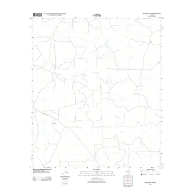
2012 Map of Hulldale SW
USGS Topo · Published 2012About this map
Duff Ranch and Henderson Ranch anchor this landscape in Tom Green County, reflecting the enduring presence of large agricultural estates in this part of Texas. The topography is defined by the ephemeral drainage patterns typical of the region, where numerous unnamed watercourses form a web across the terrain. Transport is centered on a handful of established thoroughfares, including the well-defined corridor of Ranch Road 915 and local arteries like Co Rd 418. These routes, along with Duff Rd and the vicinity of Case Ranch, highlight the sparse but systematic infrastructure required to connect these isolated homesteads and operations. The map provides a clear picture of how modern property divisions and road networks follow the natural contours and grazing lands established over generations.
Find a feature on this map
6 named features on this map. Tap any name to fly to it.
Don’t see what you’re looking for? This feature index may not catch every label — zoom into the map to look around manually.
Map Details
Editions of this 2012 Hulldale SW Map
This is the sole edition of this map. No revisions or reprints were ever made.
Other maps of this area

1895 · Sherwood
USGS Topo · 1:125,000

1954 · Sonora
USGS Topo · 1:250,000

1954 · San Angelo
USGS Topo · 1:250,000

1958 · Sonora
USGS Topo · 1:250,000

1958 · San Angelo
USGS Topo · 1:250,000

1964 · Eldorado NW
USGS Topo · 1:24,000
1964 · Eldorado NE
USGS Topo · 1:24,000

1964 · Moore Ranch
USGS Topo · 1:24,000

1965 · San Angelo
USGS Topo · 1:250,000
1972 · Hulldale NW
USGS Topo · 1:24,000