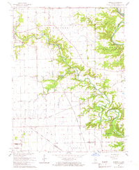
1965 Map of Humrick
USGS Topo · Published 1967About this map
The Indian Treaty Boundary cuts diagonally across this landscape, marking a historical division in the land near the Illinois Indiana border. Settlement is concentrated around small hubs like Humrick and Bethel, while the agrarian character of the mid-1960s is evidenced by numerous small family and community landmarks such as Wingard Cem and McKendree Ch. The topography is defined by the winding course of the Little Vermilion River and Vermilion River, which carve through the terrain to create distinctive formations like Horseshoe Bend and the Devils Backbone. Industrial and transport footprints are visible through the Chicago Milwaukee St Paul and Pacific rail lines and scattered mines and gravel pits, reflecting an economy built on both fertile soil and extracted resources.
Find a feature on this map
42 named features on this map. Tap any name to fly to it.
Don’t see what you’re looking for? This feature index may not catch every label — zoom into the map to look around manually.
Map Details
Editions of this 1965 Humrick Map
2 editions found
Other maps of this area

1899 · Danville
USGS Topo · 1:62,500

1900 · Danville
USGS Topo · 1:62,500

1947 · Ridge Farm
USGS Topo · 1:62,500

1949 · Danville SW
USGS Topo · 1:24,000

1950 · Danville SW
USGS Topo · 1:24,000

1950 · Danville SE
USGS Topo · 1:24,000

1951 · Danville SE
USGS Topo · 1:24,000

1953 · Danville
USGS Topo · 1:250,000

1953 · Indianapolis
USGS Topo · 1:250,000

1955 · Danville
USGS Topo · 1:250,000