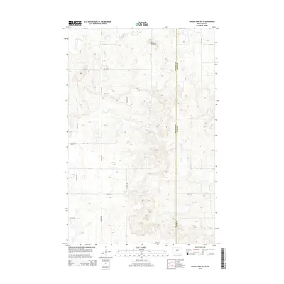
2014 Map of Hungry Man Butte
USGS Topo · Published 2014About this map
Hungry Man Butte and Rocky Hill define the high ground of this western North Dakota landscape, situated along the boundary between Billings and Dunn counties. The drainage pattern is established by the Knife River, which flows across the northern reaches of the quadrangle, supported by several tributaries including Crooked Cr and Horse Cr. The area is characterized by a sparse, remote road network consisting of numbered section-line routes such as 12th St SW and 20th St SW, which facilitate access to the surrounding ranchland. A specialized route, A Prairie Trl, suggests the continued use of traditional paths through the prairie terrain. This 2014 survey documents the enduring rural character of the region, where the natural topography of buttes and river valleys remains the primary influence on movement and land division.
Find a feature on this map
15 named features on this map. Tap any name to fly to it.
Don’t see what you’re looking for? This feature index may not catch every label — zoom into the map to look around manually.
Map Details
Editions of this 2014 Hungry Man Butte Map
This is the sole edition of this map. No revisions or reprints were ever made.
Other maps of this area

1953 · Watford City
USGS Topo · 1:250,000

1957 · Watford City
USGS Topo · 1:250,000

1963 · Fairfield SE
USGS Topo · 1:24,000

1963 · Fairfield
USGS Topo · 1:24,000

1963 · Rattlesnake Butte
USGS Topo · 1:24,000

1963 · Hungry Man Butte
USGS Topo · 1:24,000

1967 · Watford City
USGS Topo · 1:250,000
1973 · New Hradec North
USGS Topo · 1:24,000

1973 · Manning NW
USGS Topo · 1:24,000

1974 · Killdeer
USGS Topo · 1:100,000