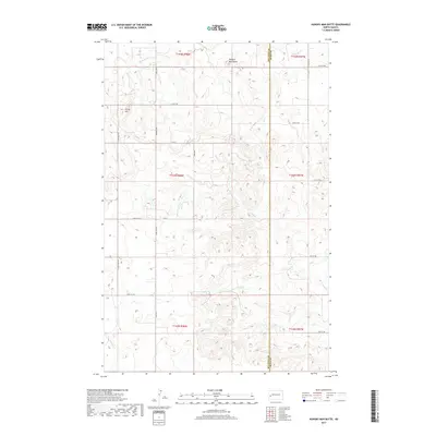
2017 Map of Hungry Man Butte
USGS Topo · Published 2017About this map
Hungry Man Butte and Rocky Hill define the high ground of this western North Dakota landscape on the boundary between Billings and Dunn counties. The drainage pattern is dominated by the Knife River in the north and the winding course of Crooked Creek to the east. This 2017 survey reveals a strictly organized section-line road network, where routes like 14th St SW and 17th St SW provide access across the high plains. The terrain is characteristic of the Missouri Plateau, showing the intricate erosional features and creek beds like Horse Creek that shape the Missouri River watershed. While the area remains largely undeveloped, the map provides precise locations for topographical landmarks and the intersection of various townships including t143n r98w and t144n r97w.
Find a feature on this map
22 named features on this map. Tap any name to fly to it.
Don’t see what you’re looking for? This feature index may not catch every label — zoom into the map to look around manually.
Map Details
Editions of this 2017 Hungry Man Butte Map
This is the sole edition of this map. No revisions or reprints were ever made.
Other maps of this area

1953 · Watford City
USGS Topo · 1:250,000

1957 · Watford City
USGS Topo · 1:250,000

1963 · Fairfield SE
USGS Topo · 1:24,000

1963 · Fairfield
USGS Topo · 1:24,000

1963 · Rattlesnake Butte
USGS Topo · 1:24,000

1963 · Hungry Man Butte
USGS Topo · 1:24,000

1967 · Watford City
USGS Topo · 1:250,000
1973 · New Hradec North
USGS Topo · 1:24,000

1973 · Manning NW
USGS Topo · 1:24,000

1974 · Killdeer
USGS Topo · 1:100,000