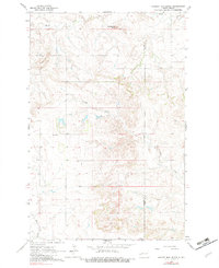
1978 Map of Hungry Man Butte
USGS Topo · Published 1982About this map
Hungry Man Butte dominates the northern landscape of this Western North Dakota survey, a prominent landmark in the high plains terrain between the Knife River and the winding course of Crooked Creek. The map documents a sparsely settled ranching and farming region during the early 1960s, with a primary focus on the small community of Snow. This area, situated along the border of Billings and Dunn Counties, features the Snow Sch, reflecting the localized educational infrastructure that served rural families of the era. The drainage patterns are clearly defined by Horse Creek and several unnamed tributaries, while Rocky Hill provides further topographic variety to this section of the Missouri Plateau.
Find a feature on this map
8 named features on this map. Tap any name to fly to it.
Don’t see what you’re looking for? This feature index may not catch every label — zoom into the map to look around manually.
Map Details
Editions of this 1978 Hungry Man Butte Map
This is the sole edition of this map. No revisions or reprints were ever made.
Other maps of this area

1953 · Watford City
USGS Topo · 1:250,000

1957 · Watford City
USGS Topo · 1:250,000

1963 · Fairfield SE
USGS Topo · 1:24,000

1963 · Fairfield
USGS Topo · 1:24,000

1963 · Rattlesnake Butte
USGS Topo · 1:24,000

1963 · Hungry Man Butte
USGS Topo · 1:24,000

1967 · Watford City
USGS Topo · 1:250,000
1973 · New Hradec North
USGS Topo · 1:24,000

1973 · Manning NW
USGS Topo · 1:24,000

1974 · Killdeer
USGS Topo · 1:100,000