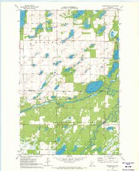
1970 Map of Huntersville
USGS Topo · Published 1972About this map
Huntersville State Forest dominates the southern half of this 1970s landscape, where the Shell River meanders eastward to its confluence with the Crow Wing River. The terrain is defined by a dense network of glacial lakes, including the large Duck Lake and a string of bodies such as Third Crow Wing Lake and Second Crow Wing Lake along the eastern boundary.
Find a feature on this map
20 named features on this map. Tap any name to fly to it.
Don’t see what you’re looking for? This feature index may not catch every label — zoom into the map to look around manually.
Map Details
Editions of this 1970 Huntersville Map
This is the sole edition of this map. No revisions or reprints were ever made.
Other maps of this area

1953 · Brainerd
USGS Topo · 1:250,000

1957 · Brainerd
USGS Topo · 1:250,000

1958 · Brainerd
USGS Topo · 1:250,000

1965 · Brainerd
USGS Topo · 1:250,000

1969 · Park Rapids
USGS Topo · 1:24,000

1969 · Menahga
USGS Topo · 1:24,000

1969 · Sebeka
USGS Topo · 1:24,000
1969 · Nimrod
USGS Topo · 1:24,000

1969 · Burgen Lake
USGS Topo · 1:24,000

1970 · Nevis
USGS Topo · 1:24,000