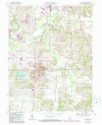
1969 Map of Huntingburg
USGS Topo · Published 1990About this map
Huntingburg serves as the industrial and transportation hub for Dubois County on this survey, centered on the Southern railroad line. The landscape is defined by the winding course of the Patoka River and its numerous tributaries, including Straight River and Hunley Creek. To the north, the outskirts of Jasper begin to emerge, while smaller settlements like Maltersville and Fairmount dot the surrounding townships. Local industry and utility are evidenced by several kilns and a claypit, alongside specialized infrastructure like the Huntingburg Airport and the Drive-in Theater near the river. Water resources are prominent, with both Knebel Lake and Huntingburg Lake appearing as significant landmarks. The map also documents essential community sites for genealogists, such as Hagen Cem and St Josephs Hospital.
Find a feature on this map
49 named features on this map. Tap any name to fly to it.
Don’t see what you’re looking for? This feature index may not catch every label — zoom into the map to look around manually.
Map Details
Editions of this 1969 Huntingburg Map
Other maps of this area

1900 · St Meinrad
USGS Topo · 1:62,500

1900 · De Gonia Springs
USGS Topo · 1:62,500

1902 · Ditney
USGS Topo · 1:125,000

1902 · Degonia Springs
USGS Topo · 1:62,500

1903 · St. Meinrad
USGS Topo · 1:62,500

1903 · Velpen
USGS Topo · 1:62,500

1946 · Jasper
USGS Topo · 1:24,000

1954 · Dubois
USGS Topo · 1:24,000

1954 · Huntingburg
USGS Topo · 1:24,000

1955 · Saint Anthony
USGS Topo · 1:24,000