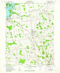
1960 Map of Huntsville
USGS Topo · Published 1962About this map
The Greenville Treaty Line bisects this Logan County landscape, marking a profound historical boundary that dictated the different surveying methods used for the lands to its north and south. In the northwest corner, the expansive waters of Indian Lake State Park feature a dense collection of named islands, including Shawnee Island and Tecumseh Island, near the recreation areas of Drums Pond and O'Connor Point. This 1960 era survey captures a settled agricultural region structured by the New York Central railroad, which links the village of Huntsville to the surrounding rural reaches.
Find a feature on this map
37 named features on this map. Tap any name to fly to it.
Don’t see what you’re looking for? This feature index may not catch every label — zoom into the map to look around manually.
Map Details
Editions of this 1960 Huntsville Map
Other maps of this area

1913 · Alger
USGS Topo · 1:48,000

1913 · Bellefontaine
USGS Topo · 1:48,000

1913 · East Liberty
USGS Topo · 1:62,500

1915 · Alger
USGS Topo · 1:62,500

1915 · Bellefontaine
USGS Topo · 1:62,500

1915 · East Liberty
USGS Topo · 1:62,500

1915 · Kenton
USGS Topo · 1:62,500

1943 · Alger
USGS Topo · 1:62,500

1944 · East Liberty
USGS Topo · 1:62,500

1944 · Kenton
USGS Topo · 1:62,500