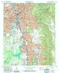
1975 Map of Huntsville
USGS Topo · Published 1993About this map
Monte Sano dominates the eastern skyline, providing a topographic anchor for Huntsville as the city expanded southward during the late twentieth century. This survey illustrates the distinct transition from the established urban core near the Von Braun Civic Center to the developing residential enclaves of Flemington Heights and Willowbrook Estates. Along the western edge, the restricted grounds of the Redstone Arsenal represent the area's massive mid-century federal investment, while the Wheeler National Wildlife Refuge preserves the wetlands around Byrd Spring Lake. Genealogists will find significant detail in the numerous family-named burial grounds like McDonnell Cem, Jones Cem, and Lanier Cem, which persist even as new suburban roads like Weatherly Road began to reshape the landscape. The map also records the influence of the Southern RR and the early layout of West Huntsville.
Find a feature on this map
132 named features on this map. Tap any name to fly to it.
Don’t see what you’re looking for? This feature index may not catch every label — zoom into the map to look around manually.
Map Details
Editions of this 1975 Huntsville Map
3 editions found
Other maps of this area

1888 · Scottsboro
USGS Topo · 1:125,000

1888 · Huntsville
USGS Topo · 1:125,000

1892 · Huntsville
USGS Topo · 1:125,000

1892 · Scottsboro
USGS Topo · 1:125,000

1936 · Jeff
USGS Topo · 1:24,000

1936 · Triana
USGS Topo · 1:24,000

1936 · New Hope
USGS Topo · 1:24,000

1936 · Madison
USGS Topo · 1:24,000

1936 · Meridianville
USGS Topo · 1:24,000

1936 · Moontown
USGS Topo · 1:24,000