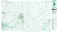
1984 Map of Huntsville
USGS Topo · Published 1986About this map
Huntsville and the sprawling military grounds of the Redstone Arsenal anchor this North Alabama landscape during the mid-1980s. The map illustrates a region transitioning from the agricultural roots of the Tennessee Valley into a major hub for aerospace and defense. To the west, Athens and Decatur define the corridor along the Tennessee River, while the eastern portion of the sheet rises sharply into the Cumberland Plateau. The river itself is dominated by the broad reaches of Wheeler Lake and Guntersville Lake, which reshaped the geography of northern Alabama counties. Rural life persists in the small settlements of Elkmont, Veto, and Pettusville near the Tennessee state line. Natural landmarks like Monte Sano State Park and the rugged Skyline Wildlife Management Area provide a stark contrast to the growing suburban developments at Western Hills Estates and Rainbow Mountain Heights.
Find a feature on this map
199 named features on this map. Tap any name to fly to it.
Don’t see what you’re looking for? This feature index may not catch every label — zoom into the map to look around manually.
Map Details
Editions of this 1984 Huntsville Map
3 editions found
Other maps of this area

1885 · Gadsden
USGS Topo · 1:125,000

1886 · Stevenson
USGS Topo · 1:125,000

1888 · Cullman
USGS Topo · 1:125,000

1888 · Gadsden
USGS Topo · 1:125,000

1888 · Scottsboro
USGS Topo · 1:125,000

1888 · Huntsville
USGS Topo · 1:125,000

1892 · Cullman
USGS Topo · 1:125,000

1892 · Huntsville
USGS Topo · 1:125,000

1892 · Scottsboro
USGS Topo · 1:125,000

1892 · Stevenson
USGS Topo · 1:125,000