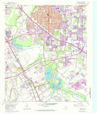
1958 Map of Hutchins
USGS Topo · Published 1985About this map
The Trinity River corridor southeast of Dallas defines this landscape, where the riparian bottomlands of Fivemile Creek and Prairie Creek meet industrial and residential growth. This 1958 survey, with revisions through the early 1970s, captures a transitional era for satellite communities like Hutchins, Balch Springs, and Kleberg. The map documents a significant concentration of private sporting and social landmarks along the river, including the Fin and Feather Club Lake and the Dallas Hunting and Fishing Club Lake.
Find a feature on this map
57 named features on this map. Tap any name to fly to it.
Don’t see what you’re looking for? This feature index may not catch every label — zoom into the map to look around manually.
Map Details
Editions of this 1958 Hutchins Map
5 editions found
Other maps of this area

1891 · Dallas
USGS Topo · 1:125,000

1893 · Dallas
USGS Topo · 1:125,000

1931 · Carrollton
USGS Topo · 1:62,500

1954 · Dallas
USGS Topo · 1:250,000

1957 · White Rock Lake
USGS Topo · 1:24,000

1958 · Dallas
USGS Topo · 1:250,000

1958 · Hutchins
USGS Topo · 1:24,000

1958 · Oak Cliff
USGS Topo · 1:24,000

1958 · Dallas
USGS Topo · 1:24,000

1958 · White Rock Lake
USGS Topo · 1:24,000