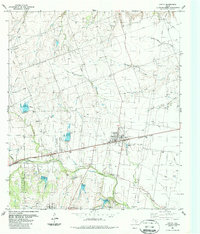
1987 Map of Hutto
USGS Topo · Published 1987About this map
Hutto and the small settlement of Monodale occupy this landscape dominated by the branching tributaries of Mustang Creek and Brushy Creek. The Missouri Pacific railroad cuts a direct horizontal line across the center of the sheet, anchoring the local transit network as it passes through the heart of the community. Rural life is evidenced by the numerous wells and gravel pits scattered across the terrain, alongside family and community landmarks like the Hutto City Cem and Smith Chapel.
Find a feature on this map
28 named features on this map. Tap any name to fly to it.
Don’t see what you’re looking for? This feature index may not catch every label — zoom into the map to look around manually.
Map Details
Editions of this 1987 Hutto Map
This is the sole edition of this map. No revisions or reprints were ever made.
Other maps of this area

1885 · Taylor
USGS Topo · 1:125,000

1885 · Bastrop
USGS Topo · 1:125,000

1887 · Taylor
USGS Topo · 1:125,000

1893 · Georgetown
USGS Topo · 1:125,000

1893 · Bastrop
USGS Topo · 1:125,000

1894 · Taylor
USGS Topo · 1:125,000

1896 · Austin
USGS Topo · 1:125,000

1897 · Austin
USGS Topo · 1:125,000

1904 · Bastrop
USGS Topo · 1:125,000

1910 · Austin
USGS Topo · 1:125,000