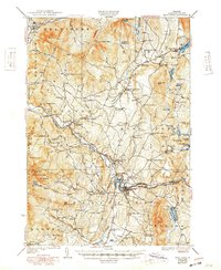
1930 Map of Hyde Park
USGS Topo · Published 1949About this map
Morrisville and the town of Hyde Park anchor this Lamoille County landscape as it appeared during the late 1920s. The Lamoille River serves as the central artery for the region, feeding into Lake Lamoille and passing landmarks like Itiel Falls and the Fairgrounds. Industrial activity is evident at the Talc Mine near North Hyde Park and within the Upper Diggings and Lower Diggings districts. For genealogists, the map is a dense record of early 20th-century social infrastructure, identifying dozens of neighborhood schoolhouses such as Mud City School and North La Porte School, along with well-established burial grounds like Mountain View Cemetery. Higher elevations include Laraway Mountain and White Face Mountain, where the Long Trail traverses the ridgelines. The southeastern corner is dominated by Elmore Mountain overlooking Elmore Pond, illustrating the mix of agricultural valleys and timbered highlands that defined this era.
Find a feature on this map
124 named features on this map. Tap any name to fly to it.
Don’t see what you’re looking for? This feature index may not catch every label — zoom into the map to look around manually.
Map Details
Editions of this 1930 Hyde Park Map
4 editions found

Other maps of this area

1919 · Montgomery
USGS Topo · 1:62,500

1919 · Montpelier
USGS Topo · 1:62,500

1920 · Franklin Pond
USGS Topo · 1:62,500

1920 · Montgomery
USGS Topo · 1:62,500

1920 · Irasburg
USGS Topo · 1:62,500

1921 · Richmond
USGS Topo · 1:48,000

1921 · Montpelier
USGS Topo · 1:62,500

1922 · Enosburg Falls
USGS Topo · 1:48,000

1923 · Irasburg
USGS Topo · 1:48,000

1924 · Camels Hump
USGS Topo · 1:62,500