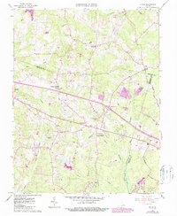
1963 Map of Hylas
USGS Topo · Published 1987About this map
Rockville and the surrounding rural landscape of Goochland and Hanover Counties are captured during a period of infrastructure expansion in the mid-1960s. The terrain is defined by the South Anna River to the north and the expansive Big Swamp to the south, with the Tuckahoe Creek drainage system carving through the center. This survey documents the early footprint of Interstate 64, including Interchange 33, which began to alter the traditional character of settlements like Johnsons Springs and Centerville. Local life is anchored by community landmarks such as the Rockville Sch, St Matthews Ch (Dry), and the Deep Run Hunt Club. The map also details the industrial and utility corridors of the era, from a local Quarry to the prominent Pipeline and Radio Tower installations that cross the wooded ridges and creek bottoms.
Find a feature on this map
38 named features on this map. Tap any name to fly to it.
Don’t see what you’re looking for? This feature index may not catch every label — zoom into the map to look around manually.
Map Details
Editions of this 1963 Hylas Map
3 editions found
Other maps of this area

1890 · Goochland
USGS Topo · 1:125,000

1892 · Goochland
USGS Topo · 1:125,000

1936 · Richmond West
USGS Topo · 1:24,000

1936 · Glen Allen
USGS Topo · 1:24,000

1941 · Glen Allen
USGS Topo · 1:31,680

1942 · Westhampton
USGS Topo · 1:31,680

1943 · Mabelton
USGS Topo · 1:31,680

1943 · Fine Creek Mills
USGS Topo · 1:31,680
1943 · Hanover Academy
USGS Topo · 1:31,680

1943 · Perkinsville
USGS Topo · 1:31,680