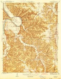
1944 Map of Iconium
USGS Topo · Published 1944About this map
The Osage River dominates the northwestern landscape of this 1940s survey, carving a dramatic loop known as Horseshoe Bend past Cedar Point. This terrain is defined by a dense network of ridges and hollows, such as Collins Hollow, where small rural communities like Iconium and Corbin serve as the primary nodes of settlement. The distribution of landmark schools, including Liberty Sch and Square Prairie Sch, indicates a decentralized educational system that catered to the farming families scattered across the borderlands of St. Clair and Hickory counties.
Find a feature on this map
33 named features on this map. Tap any name to fly to it.
Don’t see what you’re looking for? This feature index may not catch every label — zoom into the map to look around manually.
Map Details
Editions of this 1944 Iconium Map
2 editions found
Other maps of this area

1884 · Bolivar
USGS Topo · 1:125,000

1886 · Stockton
USGS Topo · 1:125,000

1887 · Clinton
USGS Topo · 1:125,000

1887 · Warsaw
USGS Topo · 1:125,000

1892 · Bolivar
USGS Topo · 1:125,000

1894 · Warsaw
USGS Topo · 1:125,000

1894 · Clinton
USGS Topo · 1:125,000

1938 · Vista
USGS Topo · 1:24,000

1939 · Osceola
USGS Topo · 1:24,000

1940 · Osceola
USGS Topo · 1:24,000