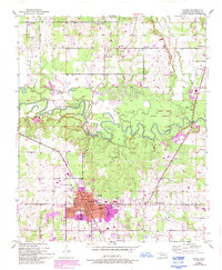
1950 Map of Idabel
USGS Topo · Published 1993About this map
Idabel serves as the hub of this McCurtain County landscape, shown here at the midpoint of the twentieth century with later revisions reflecting its mid-1990s urban expansion. The town is anchored by civic markers such as the Courthouse and Armory, while a network of rural schools including Herndon Sch and Washington Sch illustrates the educational infrastructure of the era. The meandering Little River dominates the central portion of the map, flowing through a designated National Wildlife Area and flanked by numerous oxbow lakes like Thomas Lake and Twin Lake.
Find a feature on this map
40 named features on this map. Tap any name to fly to it.
Don’t see what you’re looking for? This feature index may not catch every label — zoom into the map to look around manually.
Map Details
Editions of this 1950 Idabel Map
3 editions found
Other maps of this area

1902 · Lukfata
USGS Topo · 1:125,000

1950 · Mcalester
USGS Topo · 1:250,000

1950 · Idabel
USGS Topo · 1:24,000

1950 · Acworth
USGS Topo · 1:24,000

1950 · Shults
USGS Topo · 1:24,000

1950 · Haworth
USGS Topo · 1:24,000

1951 · Idabel
USGS Topo · 1:24,000

1951 · Garvin
USGS Topo · 1:24,000

1951 · Idabel SE
USGS Topo · 1:24,000

1951 · Haworth
USGS Topo · 1:24,000