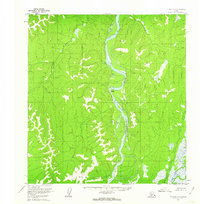
1954 Map of Iditarod A-1
USGS Topo · Published 1962About this map
The Kuskokwim River dominates this interior landscape as it winds through a series of dramatic bends, including the prominent Devils Elbow. Surveyed in the early 1950s, this area of the Iditarod region shows a wilderness primarily traversed by water and air, evidenced by the presence of Wasky Cabins along the riverbank. This small outpost serves as a rare sign of human habitation in a territory defined by complex drainage patterns and high elevations. Surveyors utilized several triangulation stations to map this terrain, such as VABM 1324 Wasky and VABM 1483 Tatla, which crown the surrounding ridges. To the west, the Nunsatuk River feeds into the valley, illustrating the intricate network of tributaries that sustain the Yukon-Koyukuk region.
Find a feature on this map
7 named features on this map. Tap any name to fly to it.
Don’t see what you’re looking for? This feature index may not catch every label — zoom into the map to look around manually.
Map Details
Editions of this 1954 Iditarod A-1 Map
2 editions found
Other maps of this area

1949 · McGrath
USGS Topo · 1:250,000

1950 · Sleetmute
USGS Topo · 1:250,000

1950 · McGrath
USGS Topo · 1:250,000

1951 · Lime Hills
USGS Topo · 1:250,000

1951 · Iditarod
USGS Topo · 1:250,000

1954 · Sleetmute D-1
USGS Topo · 1:63,360

1954 · Sleetmute D-2
USGS Topo · 1:63,360

1954 · Iditarod B-1
USGS Topo · 1:63,360

1954 · Iditarod A-1
USGS Topo · 1:63,360

1954 · McGrath B-6
USGS Topo · 1:63,360