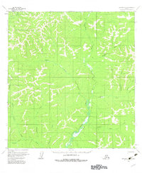
1954 Map of Iditarod B-3
USGS Topo · Published 1983About this map
The George River defines this portion of the Alaska interior, winding southward through an intricate network of tributaries that reflects the region's gold-seeking history. Based on aerial photography from the mid-1950s, the map documents a landscape where seasonal movement was dictated by the Winter Trail and established Tractor Trail routes. These paths provided critical access for miners and trappers between drainage basins like Bonanza Creek and Eldorado Creek, names that evoke the prospecting era. The mapping of Homestake Creek and Granite Creek further underscores the geological interests of the period, while the complex system of creeks such as Willow Creek and Little Moose Creek illustrates the intricate drainage patterns of the Yukon-Koyukuk region before more modern developments altered these traditional corridors.
Find a feature on this map
15 named features on this map. Tap any name to fly to it.
Don’t see what you’re looking for? This feature index may not catch every label — zoom into the map to look around manually.
Map Details
Editions of this 1954 Iditarod B-3 Map
3 editions found
Other maps of this area

1951 · Iditarod
USGS Topo · 1:250,000

1954 · Iditarod C-4
USGS Topo · 1:63,360

1954 · Iditarod A-4
USGS Topo · 1:63,360

1954 · Iditarod B-2
USGS Topo · 1:63,360

1954 · Iditarod A-3
USGS Topo · 1:63,360

1954 · Iditarod A-2
USGS Topo · 1:63,360

1954 · Iditarod C-3
USGS Topo · 1:63,360

1954 · Iditarod B-3
USGS Topo · 1:63,360

1954 · Iditarod C-2
USGS Topo · 1:63,360

1954 · Iditarod B-4
USGS Topo · 1:63,360