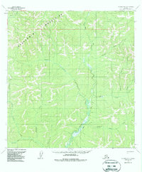
1954 Map of Iditarod B-3
USGS Topo · Published 1988About this map
The Kuskokwim Mountains dominate this 1950s interior Alaskan landscape, characterized by a complex drainage network that flows into the George River. Human activity in this territory is evidenced by a solitary Cabin and the presence of a Winter Trail cutting through the northern peaks. These trails were critical for movement before modern infrastructure, connecting remote watercourses like Bonanza Creek and Beaver Creek. The naming of tributaries such as Eldorado Creek, Bismark Creek, and Homestake Creek suggests the area's history with early prospecting, as miners named these remote reaches after their hopes for mineral wealth. Other drainages like Little Moose Creek, Willow Creek, and Michigan Creek define the local topography, showing the intricate watershed that supported early seasonal travel and resource extraction in the Alaskan bush.
Find a feature on this map
16 named features on this map. Tap any name to fly to it.
Don’t see what you’re looking for? This feature index may not catch every label — zoom into the map to look around manually.
Map Details
Editions of this 1954 Iditarod B-3 Map
3 editions found
Other maps of this area

1951 · Iditarod
USGS Topo · 1:250,000

1954 · Iditarod C-4
USGS Topo · 1:63,360

1954 · Iditarod A-4
USGS Topo · 1:63,360

1954 · Iditarod B-2
USGS Topo · 1:63,360

1954 · Iditarod A-3
USGS Topo · 1:63,360

1954 · Iditarod A-2
USGS Topo · 1:63,360

1954 · Iditarod C-3
USGS Topo · 1:63,360

1954 · Iditarod B-3
USGS Topo · 1:63,360

1954 · Iditarod C-2
USGS Topo · 1:63,360

1954 · Iditarod B-4
USGS Topo · 1:63,360