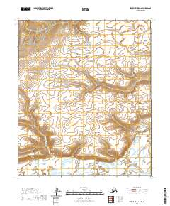
2020 Map of Ikpikpuk River A-1 NW
USGS Topo · Published 2020About this map
Kimikpak Ridge serves as the dominant landform on this remote Alaskan Arctic landscape, defining the northern relief of the quadrangle. The area is characterized by high-latitude drainage patterns and subtle elevation changes across the North Slope. These townships, including T2s R7w and T3s R7w, represent the systematic Public Land Survey System divisions in a region largely devoid of permanent human infrastructure or named water bodies. This 2020 edition provides a clear record of the tundra's topographic character, showing the intricate contouring of the ridge as it transitions into the surrounding flats. The map is a valuable resource for understanding the physical geography of the T2s R6w area before significant environmental shifts or potential future development might alter these isolated corridors.
Find a feature on this map
7 named features on this map. Tap any name to fly to it.
Don’t see what you’re looking for? This feature index may not catch every label — zoom into the map to look around manually.
Map Details
Editions of this 2020 Ikpikpuk River A-1 NW Map
This is the sole edition of this map. No revisions or reprints were ever made.
Other maps of this area

1951 · Ikpikpuk River
USGS Topo · 1:250,000

1956 · Ikpikpuk River
USGS Topo · 1:250,000
1984 · Ikpikpuk River A-1
USGS Topo · 1:63,360

1984 · Ikpikpuk River A-2
USGS Topo · 1:63,360
1985 · Ikpikpuk River B-2
USGS Topo · 1:63,360
1985 · Ikpikpuk River B-1
USGS Topo · 1:63,360
2013 · Ikpikpuk River B-2 SE
USGS Topo · 1:25,000
2013 · Ikpikpuk River B-1 SW
USGS Topo · 1:25,000
2016 · Ikpikpuk River A-2 SE
USGS Topo · 1:25,000
2016 · Ikpikpuk River A-1 SW
USGS Topo · 1:25,000