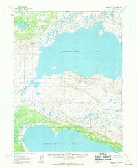
1951 Map of Iliamna A-7
USGS Topo · Published 1970About this map
Kukaklek Lake dominates the northern half of this landscape, its expansive waters interrupted only by the prominent Bear Island near the eastern shore. To the south, Nonvianuk Lake stretches across the bottom of the map, connected to the surrounding wilderness by the Nonvianuk River. Between these two massive water bodies lies a complex system of drainage and minor elevations, including the winding course of Nanuktuk Creek. The map records a sparse human presence in this region during the mid-20th century, with the exception of Hammersly Camp located near the outlet of the south lake. This camp and the headwaters of the Alagnak River highlight a region defined by its hydrography and seasonal outposts rather than permanent infrastructure, as no roads or trails were recorded at the time of the 1951 aerial surveys.
Find a feature on this map
7 named features on this map. Tap any name to fly to it.
Don’t see what you’re looking for? This feature index may not catch every label — zoom into the map to look around manually.
Map Details
Editions of this 1951 Iliamna A-7 Map
3 editions found
Other maps of this area

1948 · Mt Katmai
USGS Topo · 1:250,000

1951 · Mt Katmai
USGS Topo · 1:250,000

1951 · Mount Katmai D-5
USGS Topo · 1:63,360

1951 · Iliamna A-7
USGS Topo · 1:63,360

1951 · Mount Katmai D-4
USGS Topo · 1:63,360

1951 · Iliamna A-8
USGS Topo · 1:63,360

1951 · Iliamna B-7
USGS Topo · 1:63,360

1951 · Iliamna B-6
USGS Topo · 1:63,360

1951 · Iliamna A-6
USGS Topo · 1:63,360

1952 · Iliamna
USGS Topo · 1:250,000