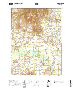
2019 Map of Iliamna D-8 NW
USGS Topo · Published 2019About this map
The Koktuli River winds through the southern reaches of this landscape in the Lake and Peninsula Borough. This 2019 survey documents a transitional Alaskan terrain where high-elevation contour lines to the north give way to an intricate network of wetlands and small ponds in the lower elevations. The map provides a detailed view of the natural drainage patterns in this part of the borough, centered on the river's path through the township divisions of t3s r39w and t3s r38w. While no man-made settlements are indicated on this remote stretch, the topography reveals the complex hydrology of the watershed as it appeared in the early twenty-first century.
Find a feature on this map
6 named features on this map. Tap any name to fly to it.
Don’t see what you’re looking for? This feature index may not catch every label — zoom into the map to look around manually.
Map Details
Editions of this 2019 Iliamna D-8 NW Map
This is the sole edition of this map. No revisions or reprints were ever made.
Other maps of this area

1946 · Lake Clark
USGS Topo · 1:250,000

1950 · Taylor Mountains
USGS Topo · 1:250,000

1951 · Lake Clark
USGS Topo · 1:250,000

1951 · Taylor Mountains
USGS Topo · 1:250,000

1951 · Dillingham
USGS Topo · 1:250,000

1952 · Iliamna
USGS Topo · 1:250,000

1954 · Lake Clark A-8
USGS Topo · 1:63,360

1954 · Iliamna D-8
USGS Topo · 1:63,360

1954 · Taylor Mountains
USGS Topo · 1:250,000

1954 · Dillingham
USGS Topo · 1:250,000