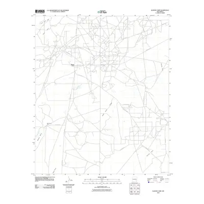
2010 Map of Illinois Camp
USGS Topo · Published 2010About this map
Illinois Camp stands as a central point of interest in this Eddy County landscape, where the infrastructure of the local petroleum industry meets the traditional ranching heritage of southeastern New Mexico. The map reveals an extensive network of roads like Oil Center Rd and Depco Rd, which weave between the drainage patterns of Angel Draw and Palmilla Draw. The topography is defined by the prominent Chalk Bluff in the northwest and the subtly rising Fade Away Ridge, which stretches across the central portion of the quadrangle. These features, alongside North Williams Ranch, illustrate the land use patterns where resource extraction and livestock ranching coexist. The intricate web of county roads and named draws provides a detailed record of the region's geography at the start of the twenty-first century, useful for understanding the evolution of this high-plains terrain.
Find a feature on this map
21 named features on this map. Tap any name to fly to it.
Don’t see what you’re looking for? This feature index may not catch every label — zoom into the map to look around manually.
Map Details
Editions of this 2010 Illinois Camp Map
This is the sole edition of this map. No revisions or reprints were ever made.
Other maps of this area

1943 · Oil City
USGS Topo · 1:62,500

1954 · Carlsbad
USGS Topo · 1:250,000

1955 · Spring Lake
USGS Topo · 1:24,000

1955 · Red Lake SE
USGS Topo · 1:24,000

1955 · Lake Mc Millan North
USGS Topo · 1:24,000

1955 · Lake Mc Millan South
USGS Topo · 1:24,000

1955 · Red Lake
USGS Topo · 1:24,000

1958 · Carlsbad
USGS Topo · 1:250,000

1978 · Artesia
USGS Topo · 1:100,000
1985 · Angel Draw
USGS Topo · 1:24,000