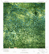
1974 Map of Immokalee 4 SE
USGS Topo · Published 1976About this map
Mullet Slough and Bamboo Strand define this intricate wetland landscape in Collier County, revealed here through a mid-1970s orthophotomap that blends aerial photography with topographic data. The map reveals the isolation and specialized land use of the Florida Everglades, where small settlements like Osceola Camp and Wagon Wheel are reached by limited trails. Human presence is marked by a series of remote airstrips, including the Little Deer Landing Strip and Quakenossee Hollow Landing Strip, which provide essential access to this saturated interior. Prominent terrain features such as Thompson Pine Island, Turkey Foot, and the Sugar Mill Mound emerge as distinct dry-ground signatures amidst the complex drainage patterns of Mud Lake and Quakenossee Hollow. The visual data provides a clear record of the vegetation density and water distribution before significant modern hydrological changes or developments altered the region's character.
Find a feature on this map
12 named features on this map. Tap any name to fly to it.
Don’t see what you’re looking for? This feature index may not catch every label — zoom into the map to look around manually.
Map Details
Editions of this 1974 Immokalee 4 SE Map
2 editions found
Other maps of this area

1956 · Miami
USGS Topo · 1:250,000

1956 · West Palm Beach
USGS Topo · 1:250,000

1957 · West Palm Beach
USGS Topo · 1:250,000

1958 · West Palm Beach
USGS Topo · 1:250,000

1958 · Miami
USGS Topo · 1:250,000

1972 · Monroe Station NE
USGS Topo · 1:24,000

1972 · Burns Lake
USGS Topo · 1:24,000

1973 · North Of Fiftymile Bend
USGS Topo · 1:24,000

1974 · Immokalee 4 NW
USGS Topo · 1:24,000
1974 · Immokalee 4 SW
USGS Topo · 1:24,000